Design concepts
At the public meeting held on Oct. 16, 2024, the study team presented three scenarios with various design options within each scenario. Those attending the meeting were asked which scenario met their needs. The following table indicates what is included in each scenario. The shaded spaces marked with a check mark are included in that scenario. Feedback from that meeting helped shape the 2.2+ scenario available to view on the part one study report (PDF).
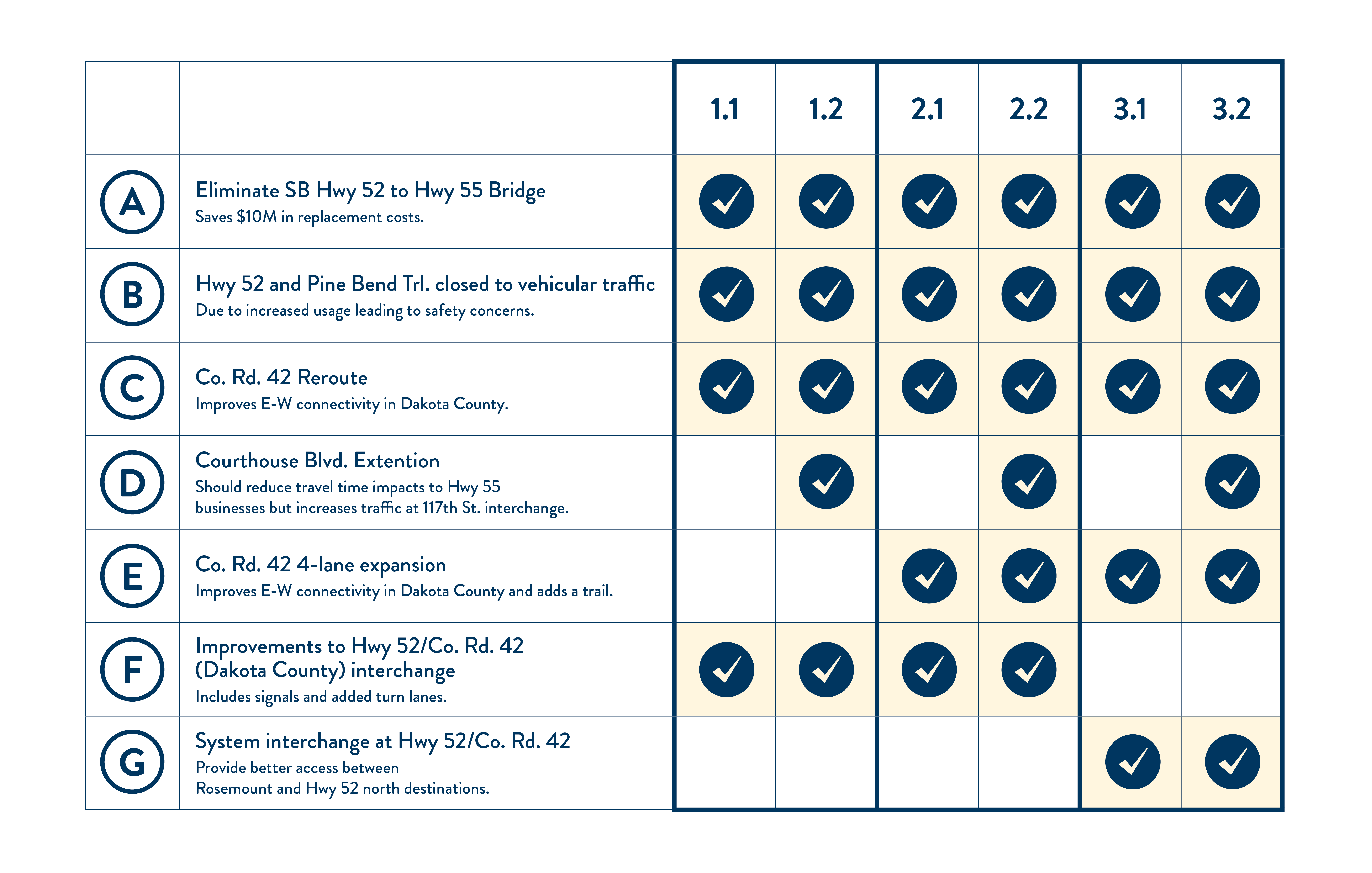
Scenario 1.1
- Eliminate Southbound Hwy 52 to Hwy 55 Bridge
- Close Hwy 52 and Pine Bend Trail to vehicle traffic
- Realign/re-route Co. Rd. 42
- Improve Hwy 52/Co. Rd. 42 interchange with capacity and signals
Scenario 1.2
- Eliminate Southbound Hwy 52 to Hwy 55 Bridge
- Close Hwy 52 and Pine Bend Trail to vehicle traffic
- Realign/re-route Co. Rd. 42
- Add Courthouse Blvd. Extension
- Improve Hwy 52/Co. Rd. interchange with capacity and signals
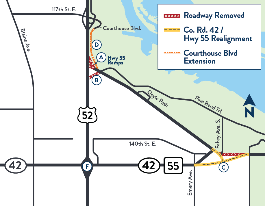
Map of the study area showing scenario 1 concepts
View full size image
Hwy 52 without the Hwy 55 bridge ramps and the Courthouse Blvd. roadway extension
View full size image
Scenario 2.1
- Eliminate Southbound Hwy 52 to Hwy 55 Bridge
- Close Hwy 52 and Pine Bend Trail to vehicle traffic
- Realign/re-route Co. Rd. 42
- Expand Co. Rd. 42 to four lanes and add trail
- Improve Hwy 52/Co. Rd. 42 interchange with capacity and signals
Scenario 2.2
- Eliminate Southbound Hwy 52 to Hwy 55 Bridge
- Close Hwy 52 and Pine Bend Trail to vehicle traffic
- Realign/re-route Co. Rd. 42
- Expand Co. Rd. 42 to four lanes and add trail
- Improve Hwy 52/Co. Rd. 42 interchange with capacity and signals
- Add Courthouse Blvd. extension
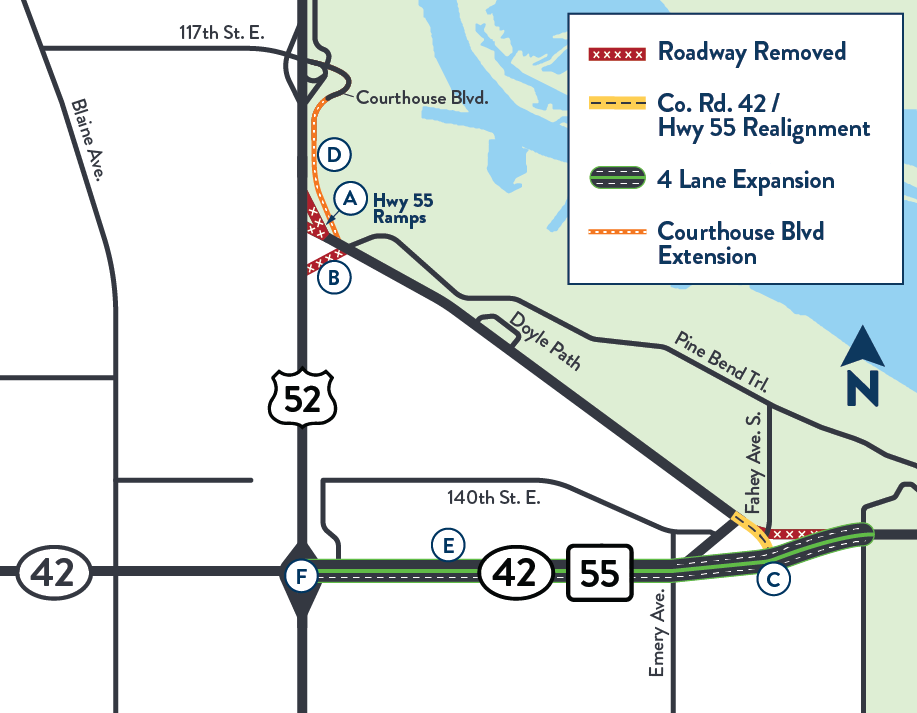
Map of the study area showing scenario 2 concepts
View full size image
Hwy 52 without the Hwy 55 bridge ramps and the Courthouse Blvd. roadway extension
View full size image
Co. Rd. 42 being expanded to a four-lane roadway with a trail
View full size image
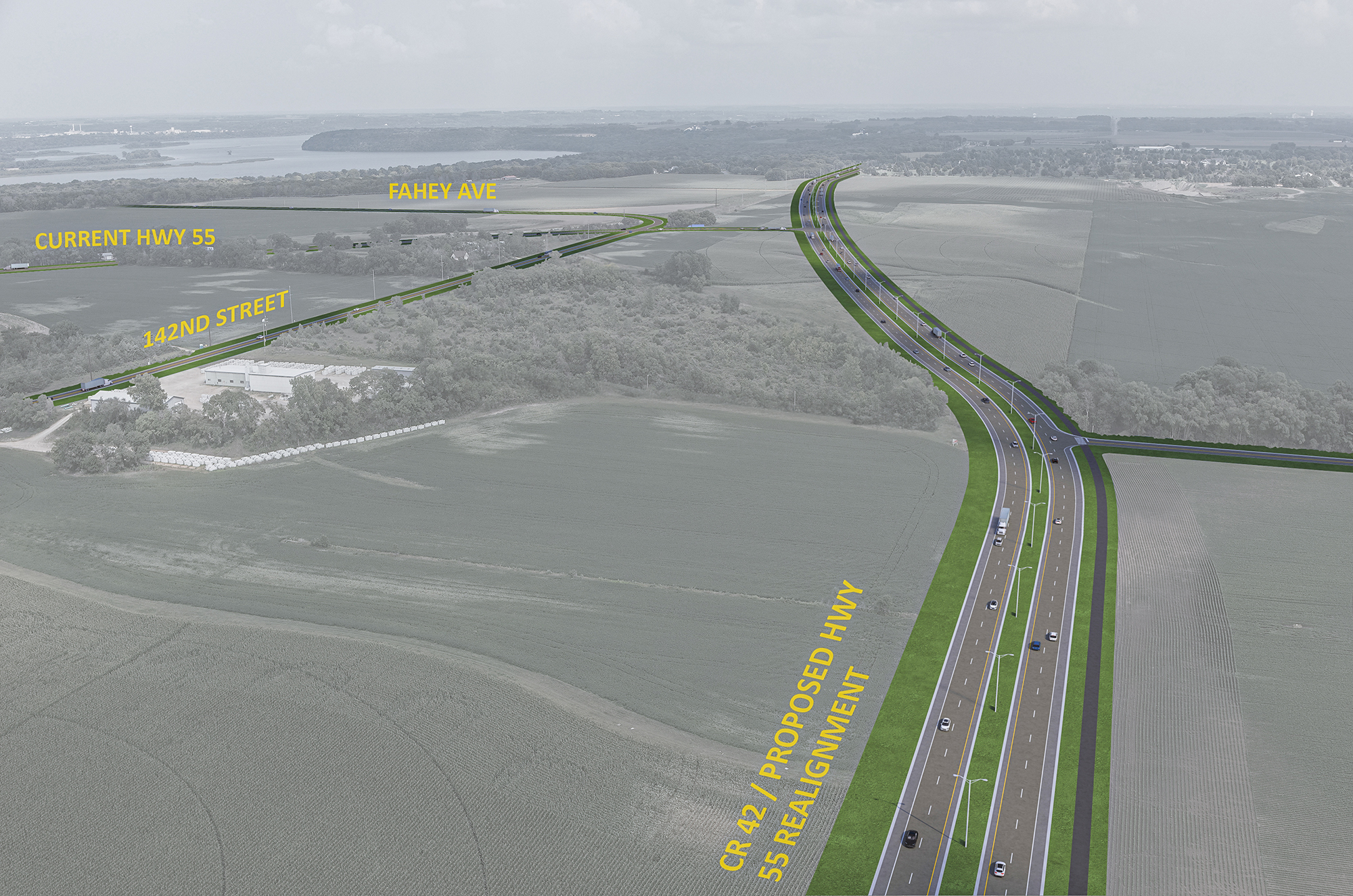
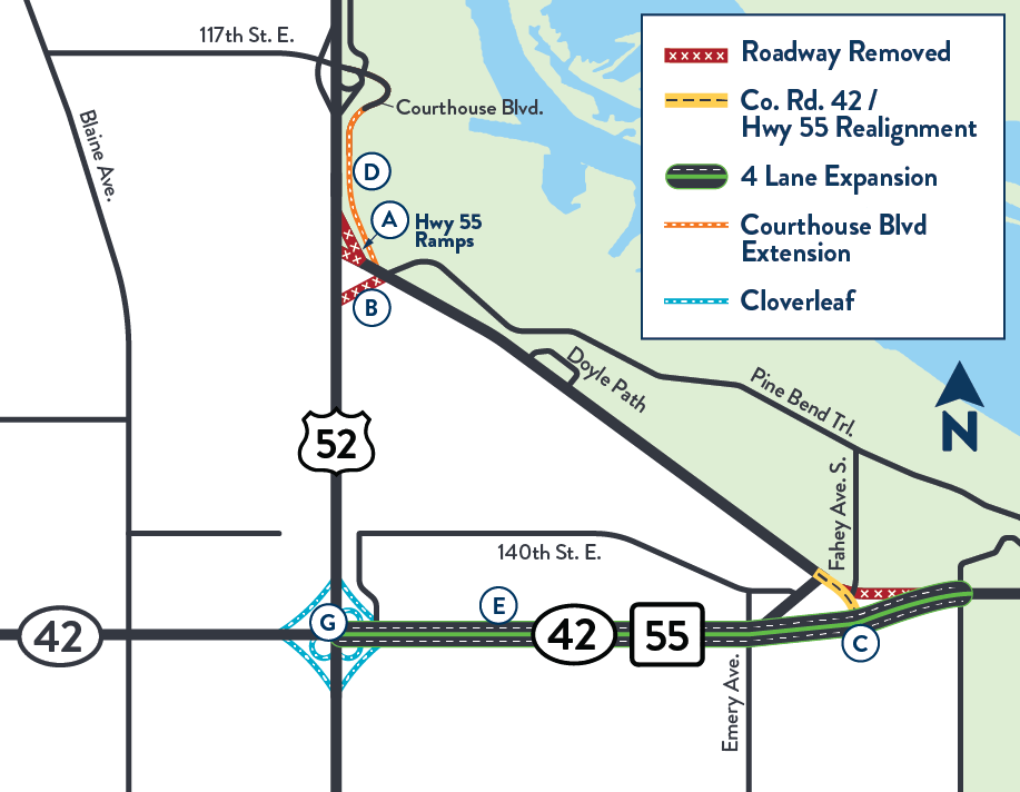
Scenario 2.2+
- Realignment of Hwy 55 to Co. Rd. 42
- Hwy 52 to Hwy 55 bridge ramps will be closed and removed
- Hwy 52 shifts to the west to provide room for Courthouse Blvd. connection
- The realigned Hwy 55/Co. Rd. 42 road will be expanded from a two-lane undivided segment to a four-lane divided segment between Hwy 52 and east of Fahey Ave.
- A shared-use path will be built on Co. Rd. 42
- Courthouse Blvd. will be extended from Hwy 55 to the 117th St. interchange to the north
- Southwest and southeast loops will be added to the Hwy 52/Co. Rd. 42 interchange
- Co. Rd. 42 realignment improves east–west connectivity in Dakota County
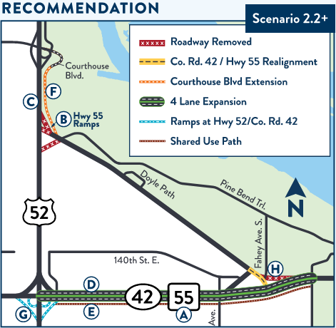
Map of the study area showing scenario 2.2 plus concepts
View full size image
Scenario 3.1
- Eliminate Southbound Hwy 52 to Hwy 55 Bridge
- Close Hwy 52 and Pine Bend Trail to vehicle traffic
- Realign/re-route Co. Rd. 42
- Expand Co. Rd. 42 to four lanes and add trail
- Add Hwy 52/Co. Rd. 42 system interchange (cloverleaf)
Scenario 3.2
- Eliminate Southbound Hwy 52 to Hwy 55 Bridge
- Close Hwy 52 and Pine Bend Trail to vehicle traffic
- Realign/re-route Co. Rd. 42
- Expand Co. Rd. 42 to four lanes and add trail
- Add Hwy 52/Co. Rd. 42 system interchange (cloverleaf)
- Add Courthouse Blvd. extension
Map of the study area showing scenario 3 concepts
View full size image
Hwy 52 without the Hwy 55 bridge ramps and the Courthouse Blvd. roadway extension
View full size image
Co. Rd. 42 being expanded to a four-lane roadway with a trail
View full size image
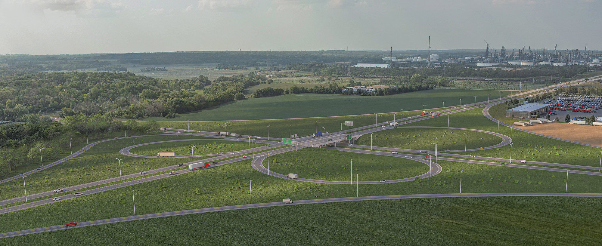
Cloverleaf interchange at Hwy 52 and Co. Rd. 42
View full size image